Difference between revisions of "Krusty Burger Fun Map"
Wikisimpsons - The Simpsons Wiki
Solar Dragon (talk | contribs) m |
(→History) |
||
| Line 13: | Line 13: | ||
== History == | == History == | ||
| − | After [[Homer]] and [[Bart]], along with [[Ned]] and [[Rod]], were lost at sea aboard a raft, Homer smelled hamburgers. According to the maps, he guided the raft to a Krusty Burger restaurant that was built on an offshore [[Krusty Burger Oil Rig|oil rig]]. | + | After [[Homer]] and [[Bart]], along with [[Ned]] and [[Rod]], were lost at sea aboard a raft during the [[Junior Campers]]' annual father-son rafting trip, Homer smelled hamburgers. According to the maps, he guided the raft to a Krusty Burger restaurant that was built on an offshore [[Krusty Burger Oil Rig|oil rig]]. |
== Behind the Laughter == | == Behind the Laughter == | ||
Latest revision as of 18:28, December 4, 2024
Krusty Burger Fun Map
| ||||||||
Object Information
|
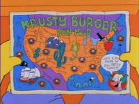
The Krusty Burger Fun Map is a map of North America that is part of Krusty Burger's merchandising, emphasizing areas where Krusty Burger branches are located.
History[edit]
After Homer and Bart, along with Ned and Rod, were lost at sea aboard a raft during the Junior Campers' annual father-son rafting trip, Homer smelled hamburgers. According to the maps, he guided the raft to a Krusty Burger restaurant that was built on an offshore oil rig.
Behind the Laughter[edit]
Mississippi is incorrectly labeled as MI. Mississippi's official postal abbreviation is MS; Michigan's is MI.

